X-Large District of Muskoka Wall Map
This map is custom printed to order. Turn-around time is approx 7-14 business days.
Shipping:
- Vinyl maps are packaged in a cardboard tube and shipped with Canada Post.
- Foamboard and Flushmount maps CAN NOT be shipped. These maps can be pickup your order in Bracebridge. OR can be delivered to an address in Muskoka for a fee of $50.
Please contact us at info@aquaterramaps.com or 705-644-9876 if you have any questions.
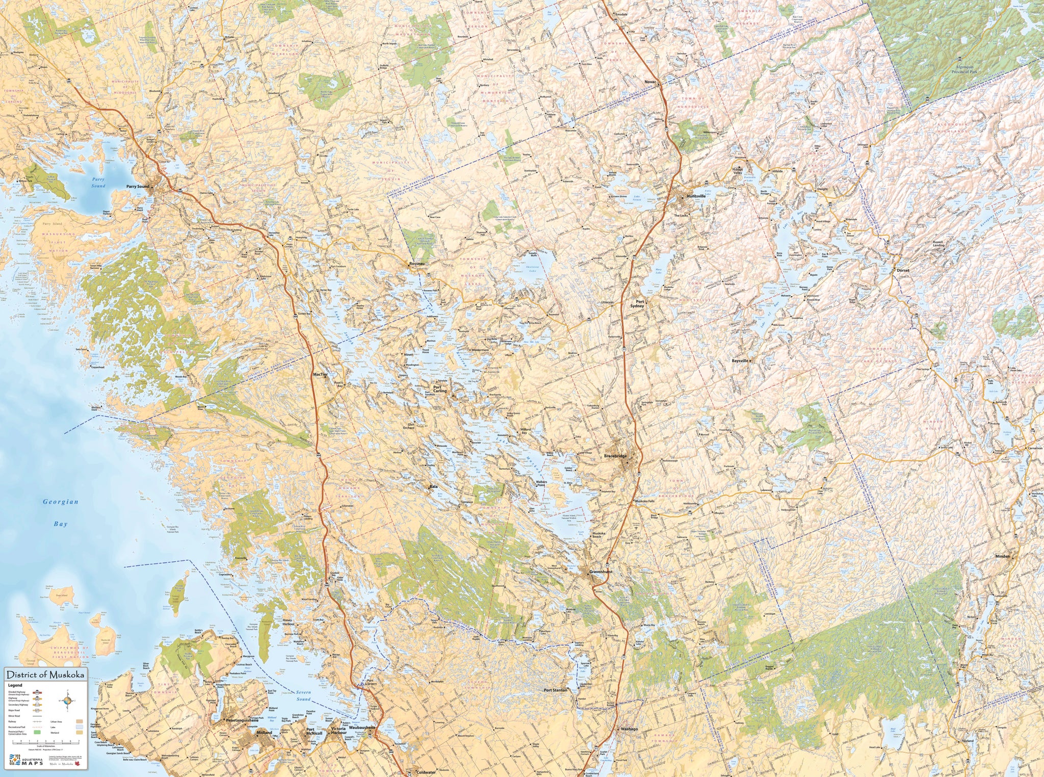
Extra Large District of Muskoka Wall Map (4′ tall x 5.25′ wide)
This large wall map covers the entire District of Muskoka. It is the only map available that shows the District of Muskoka on one map in such vivid detail. Every road is accurately shown as well as every stream, river, wetland, lake and island. In addition, land uses such as urban areas, parks and conservation areas are displayed.
The map includes a dramatic hillshade effect through which the the rugged rocky landscape of the District is displayed.
A Destination for over 100 years
This District of Muskoka stretches from the island dotted shoreline of Georgian Bay in the west to Haliburton County in the east. To the north it is bordered by the District of Parry Sound. The boundary between The District of Muskoka and Simcoe County is defined by the Severn River (Trent Severn Waterway).
Muskoka has been a tourist and second home destination for over 100 years. It is world renowned for its multitude of lakes and rivers which include the famous Muskoka Lakes (Lake Muskoka, Lake Rosseau and Lake Joseph) and other large inland lakes such as Lake of Bays, Lake Vernon, Peninsula Lake, Fairy Lake, Mary Lake and Skeleton Lake. In addition, many other lakes offer extraordinary cottage and recreation opportunities. The expansive forested areas and exceptional snow conditions in the winter make Muskoka a year round destination and home for many throughout Ontario.
Size: 4' tall x 5.25' wide
Coverage Area: The District of Muskoka and surrounding area. Includes: Town of Gravenhurst, Town of Bracebridge, Town of Huntsville, Township of Georgian Bay, Township of Muskoka Lakes, Township of Lake of Bays.
Features: Highways, Major Roads, Cottage Roads, Provincial Parks, Conservation Areas, Golf Courses, Airports, Municipal Boundaries, Towns, Villages, Hamlets, Natural Features.

Finishing Options:
Vinyl is easy to hang up and can be rolled for easy portability.
Foamboard is lightweight and looks great, with a glossy finish and can also be used with push pins.
Flushmounted is a paper print is mounted onto a 1/8" masonite, then protected by a non-glare laminate. A 3/4" box frame is mounted on the back of the masonite flush with the outside edges. The edges are finished in black. Slotted on the back, ready to hang.